 Nelson: Haulashore Island - Tāhunanui
Nelson combines a working-harbour character with a beachside setting in a way that reflects its position at the head of Tasman Bay / Te Tai-o-Aorere. Haulashore Island lies in Nelson Haven, the sheltered inlet formed behind the Boulder Bank, a long natural gravel spit that protects the port. Tāhunanui is Nelson’s coastal suburb, known for its beach and for the broad sweep of water separating it from the city’s port. Nelson was established by the New Zealand Company in 1841 and is regarded as the oldest city in New Zealand’s South Island. The meeting of harbour infrastructure, sheltered waters and the wider bay gives this compact city a distinctly maritime identity, while the Boulder Bank remains one of its defining landforms.
Generated by AI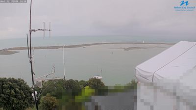






Nelson straddles the Maitai River in the Nelson region, and its position at the head of Tasman Bay has made it an urban centre for the upper South Island. Founded in 1841 by the New Zealand Company, it is commonly described as the South Island’s oldest city. Christ Church Cathedral rises above the centre on Church Hill, while the surrounding district is known for orchards, vineyards and access to the Abel Tasman coastline. Kahurangi National Park also lies nearby, protecting a vast area of mountains, forests and karst country. Browse other webcams across Nelson and Tasman to place this coastal setting in a wider geographic context.
3 webcams
Among New Zealand’s regions, Nelson stands out for its sheltered position at the top of the South Island beside Tasman Bay. The area links a compact city, also known by its Māori name Whakatū, with a northern landscape of bays, hills and productive farmland. To the northwest, Abel Tasman National Park protects a coast traversed by a celebrated walking track and explored by sea kayak; farther inland, Nelson Lakes National Park brings beech forest and alpine terrain around Lakes Rotoiti and Rotoroa. Nelson has long been associated with horticulture and hop growing, while galleries, studios and markets reinforce its creative character. Explore additional webcams nearby to understand how Nelson connects with the coast and inland ranges.
3 webcams
New Zealand combines Pacific isolation with strong ties to the wider South Pacific in a way that reflects its position between the Tasman Sea and the open Pacific Ocean. The country’s two main islands are divided by Cook Strait, while the Southern Alps run along much of the South Island and include Aoraki / Mount Cook, its highest mountain. On the North Island, volcanic terrain shapes Tongariro National Park and the central plateau; long coastlines frame cities such as Auckland and Wellington. Māori culture is central to national life, and the Treaty of Waitangi, first signed in 1840, remains a foundational document in relations between Māori and the Crown. See how New Zealand fits within the wider South Pacific by browsing webcams nearby.
491 webcams