 Umuarama
 lies on Paraná’s Third Plateau, where gently rolling uplands shape this planned city in northwestern Brazil. Founded in 1955 by Companhia Melhoramentos Norte do Paraná, it developed during the region’s mid-20th-century settlement and agricultural expansion. Broad avenues, civic squares and mature trees define the central area, alongside a compact group of taller buildings. Known in Brazil as the Capital da Amizade, Umuarama is a regional centre for commerce, education and services across northwestern Paraná. Its urban fabric reflects a newer inland Brazilian city rather than the colonial street patterns of older centres.
Generated by AI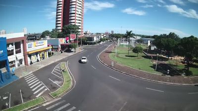

Umuarama spreads across the gently rolling plateau of northwestern Paraná, Brazil, a setting that helped turn a planned settlement into a regional centre for agriculture, commerce and services. Founded in 1955 by Companhia Melhoramentos Norte do Paraná, it grew during the organised colonisation of the state’s interior. Its Tupi-derived name is generally understood as “a place for friends to meet”, an idea echoed in its local nickname, Capital da Amizade. Lago Aratimbó, an urban lake and leisure area near the centre, provides a calmer counterpoint to the city’s commercial life. Discover other points of interest through webcams located across Umuarama and Paraná.
2 webcams
Among Brazil’s states, Paraná stands out for its span from the Atlantic coast across the Serra do Mar to the Paraná River. Forested uplands, farming country and major cities give this southern state a varied character, while the Paraná River marks much of its western frontier. In the southwest, Iguaçu National Park contains Brazil’s side of Iguaçu Falls and is recognised as a UNESCO World Heritage site. Curitiba, the state capital, reflects the immigrant traditions that have shaped Paraná, including Polish, Ukrainian, Italian and German communities. Explore related webcams around Paraná to gain a broader sense of this southern Brazilian state.
26 webcams
Brazil has served as a Portuguese colonial link between Europe and South America since the 16th century. Its immense territory extends from the Amazon River basin in the north to the Atlantic coast, with the Pantanal wetlands and Brazilian Highlands creating very different regions inland. Rio de Janeiro sits beside Guanabara Bay beneath Sugarloaf Mountain, while Brasília is known for its planned layout and modernist buildings by Oscar Niemeyer. Portuguese is the official language, and football, regional cuisines and Carnival celebrations are central to public life across the country. Continue through nearby webcams to explore different parts of Brazil.
150 webcams