 Terek Township
West Chester has served as the county seat of Chester County in southeastern Pennsylvania since 1789. Set in the rolling Piedmont uplands of the Brandywine Creek watershed, the borough combines a compact courthouse-centered core with residential streets and commercial corridors. Its brick-built center is anchored by the Chester County Courthouse, designed by Thomas Ustick Walter and completed in 1847. West Chester University, founded in 1871 as a teachers’ school, gives the town a strong academic presence. The borough belongs to the wider Brandywine Valley, an area associated with colonial-era settlement and the work of the Wyeth family.
Generated by AI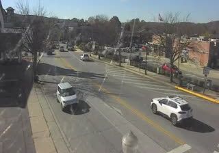







Terek Township combines the settled rhythm of irrigated farmland with the open, arid scale of western Xinjiang, reflecting its position along the western margin of the Tarim Basin. The Tian Shan rise to the north, while oasis communities across the basin rely on managed water in a dry continental climate. This wider borderland has long formed part of the cultural world linked with the Silk Road, with Uyghur and Kyrgyz traditions prominent across the region. Terek is best understood as a small rural locality within this vast inland setting rather than an urban destination. View additional webcams nearby to better understand how Terek Township relates to western Xinjiang’s surroundings.
1 webcam
Built around the oasis corridors of the Silk Road, Xinjiang grew into China’s largest provincial-level region, formally the Xinjiang Uyghur Autonomous Region. It occupies China’s far northwest, where the Tian Shan separates the Junggar Basin to the north from the Tarim Basin to the south. The Tarim River system sustains oases along the basin’s margins, while the Taklamakan Desert lies at its centre. Xinjiang’s population includes Uyghur, Han, Kazakh, Kyrgyz and Mongol communities, reflected in its languages, food and local traditions. Cities such as Turpan and Kashgar remain important links to the historic Silk Road. Explore additional webcams nearby to understand how Xinjiang’s mountains, deserts and oasis corridors extend across northwestern China.
1 webcam
Built around the Yellow River and Yangtze basins, China grew into a vast modern state with landscapes that run from the Tibetan Plateau and the Himalayas to the Gobi Desert and the shores of the South China Sea. The Yangtze, Asia’s longest river, crosses the country west to east, linking mountain regions with major cities and fertile plains. Beijing’s Forbidden City, the former imperial palace of the Ming and Qing dynasties, remains a defining monument of its long imperial era. The Great Wall follows northern terrain in many separate sections, while regional cuisines, tea traditions and festivals reveal striking local variety. Explore other places across China’s regions to put this setting in a broader geographic context.
186 webcams