 Escholzmatt-Marbach: Sportbahnen Marbachegg
Among the places of the canton of Lucerne, Marbachegg stands out for its broad alpine ridge above Marbach and its close connection to the Schrattenfluh range. At 1,483 metres, it is reached from the village by the Marbachegg cable car, operated by Sportbahnen Marbachegg, and combines grazing land with routes for walking, mountain biking and winter sports. The ridge looks across the rolling Emmental landscape toward Schrattenfluh’s rugged limestone formations. Marbach lies within the UNESCO Biosphere Entlebuch, recognised in 2001, where farms, moorland and forest form a lived-in cultural landscape. Mountain restaurants and traditional farm buildings reinforce the area’s rural character.
Generated by AI



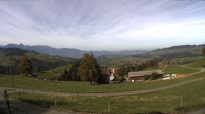


Built around farming settlements in the upper Entlebuch, Escholzmatt-Marbach grew into a rural municipality in the canton of Lucerne after its two former communes merged in 2013. It lies amid the Swiss Pre-Alps, close to the distinctive limestone ridges of the Schrattenfluh and within the UNESCO Biosphere Entlebuch. Marbach is known as the starting point for the cable car to Marbachegg, while the wider area reflects the dairy-farming traditions of central Switzerland. Find related webcams across the Entlebuch to build a fuller picture of the Lucerne countryside.
1 webcam
Luzern is best known within Switzerland for Lake Lucerne, where the Swiss Plateau meets the foothills of the Alps. The canton extends from settled farmland and rolling hills into the Prealpine landscapes of Entlebuch, a UNESCO Biosphere Reserve known for its moorlands and traditional rural scenery. In the city of Lucerne, the Reuss flows out of the lake beside the Kapellbrücke, the covered wooden bridge that has become one of Switzerland’s most recognisable landmarks. Rail and road routes have long made this central region an important link between northern Switzerland and Alpine passes. Continue with other webcams from the area to see how this part of central Switzerland connects regionally.
37 webcams
Switzerland stretches from the Jura Mountains in the northwest to the Alps in the south, encompassing a central plateau of cities, farms and lakes. The Rhine rises in the Swiss Alps, while Lake Geneva forms part of the country’s southwestern border. Zürich, Geneva and Basel are major urban centres, yet mountain railways and passes remain central to how many regions are experienced. Four national languages—German, French, Italian and Romansh—reflect Switzerland’s distinct cantonal identities. The Matterhorn above Zermatt is among Europe’s most recognisable peaks, and the 1291 Federal Charter is closely associated with the country’s founding tradition. Continue through nearby webcams to explore different parts of Switzerland.
1.4K webcams