Historical images are not available for this webcam
 Ada: I-77 - WV MM 1.2 - (West Virginia DMS)
The landscape around Ada is wooded and hilly, which has shaped both the built environment and local life. Set in southern West Virginia, Ada lies on the Appalachian Plateau, where ridges and narrow hollows guide the course of settlements and transport corridors. US Route 460 runs through this predominantly forested terrain, linking the Bluefield and Princeton area across Mercer County. The county forms part of the wider Central Appalachian coalfield, and coal extraction has influenced the economy and identity of southern West Virginia for generations. This is a rural roadside setting rather than an urban centre, defined by forested slopes, engineered highways and scattered development.
Generated by AI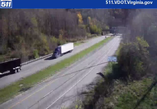










The landscape around Ada is a forested, rolling part of southern West Virginia’s Appalachian highlands, which has shaped both settlement patterns and the local economy. This small community lies in the coalfield country of Mercer County, a region whose development was closely tied to coal mining and rail transport. Ada represents the rural, wooded side of Appalachia, with nearby towns providing access to services and the wider Bluefield area. Discover other points of interest through webcams located across West Virginia.
3 webcams
Among the states of the United States, West Virginia stands out for its deeply folded Appalachian terrain and enduring mountain identity. The Allegheny Mountains, forested ridges, and narrow river valleys shape much of the state, while the New River cuts through the dramatic gorge protected by New River Gorge National Park and Preserve. Coal mining has long influenced local communities and the state’s industrial heritage. West Virginia became a separate state during the Civil War in 1863. Continue through nearby webcams to explore different parts of West Virginia.
11 webcams
The Atlantic, Pacific and Gulf coasts define much of the United States — their ports, fisheries and trade routes have long tied the country’s economy to the wider world. Between them, the Rocky Mountains, Great Plains and Mississippi River basin form sharply different regions, from high western ranges to broad agricultural heartlands. Cities carry much of the national story: New York’s Statue of Liberty, a gift from France dedicated in 1886, remains an enduring symbol, while Washington, DC concentrates major federal institutions. Indigenous nations have shaped these lands for millennia, and their living cultures remain essential to the country’s identity. Find related webcams in the surrounding areas to build a fuller picture of the United States.
32K webcams