 Lincoln: Main Street
Lincoln straddles the upper Blackfoot River in western Montana, and its position in a narrow mountain valley has made it a practical stop on US Highway 200 between Helena and Missoula. Main Street is the community’s central corridor, where local services line the route through conifer forest and public lands. Mining and logging shaped Lincoln’s development, helping explain its working, roadside character. Much of the surrounding country belongs to the Helena–Lewis and Clark National Forest. The Blackfoot River is closely associated with Montana writer Norman Maclean’s A River Runs Through It, adding a literary context to this remote part of the state.
Generated by AI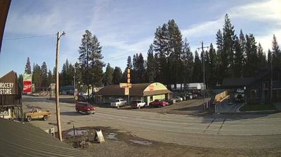

The Blackfoot River shapes the setting of Lincoln — its valley forms a settled corridor through Montana’s forested Continental Divide country, with conifer-clad slopes close to town. This small community sits amid extensive public land, including country associated with the Scapegoat Wilderness and the larger Bob Marshall Wilderness Complex. Lincoln is also home to Blackfoot Pathways: Sculpture in the Wild, an outdoor art park where large-scale contemporary works are placed among meadows and woodland. Fishing, hiking and seasonal wildlife watching are part of the local rhythm, while the town remains a practical stop on routes between central and western Montana. Continue with other webcams from the area to see how this part of western Montana connects regionally.
2 webcams
Montana extends from the Rocky Mountains in the west to the Great Plains along its eastern border, encompassing high ranges, wide river valleys and open prairie. The Missouri River crosses the state’s centre, beginning near Three Forks where the Jefferson, Madison and Gallatin rivers meet. Glacier National Park protects a dramatic section of the northern Rockies, while Little Bighorn Battlefield National Monument commemorates the 1876 battle between U.S. forces and Lakota and Cheyenne warriors. Ranching, tribal nations and long-distance rail corridors remain central to Montana’s identity. Find related webcams across the surrounding states to build a fuller picture of Montana.
44 webcams
The Atlantic, Pacific and Gulf coasts define much of the United States — their ports, fisheries and trade routes have long tied the country’s economy to the wider world. Between them, the Rocky Mountains, Great Plains and Mississippi River basin form sharply different regions, from high western ranges to broad agricultural heartlands. Cities carry much of the national story: New York’s Statue of Liberty, a gift from France dedicated in 1886, remains an enduring symbol, while Washington, DC concentrates major federal institutions. Indigenous nations have shaped these lands for millennia, and their living cultures remain essential to the country’s identity. Find related webcams in the surrounding areas to build a fuller picture of the United States.
32K webcams