 Kotschach-Mauthen: Rauchkofel - Coglians
Built around a route towards the Plöcken Pass, Kötschach-Mauthen grew into a market town in Carinthia’s Gail Valley. The Gail River follows this broad Alpine valley beneath the Carnic Alps, a range that forms much of the Austrian–Italian frontier. Coglians, known in Austria as the Hohe Warte, is the highest summit in the Carnic Alps; Rauchkofel is another prominent peak of this borderland. The municipality unites the formerly separate settlements of Kötschach and Mauthen, whose name recalls a historic customs post on the pass route. The local Museum 1915–18 documents the First World War mountain front around the Plöcken Pass, while valley cycling and mountain routes remain central to the area’s active character.
Generated by AI
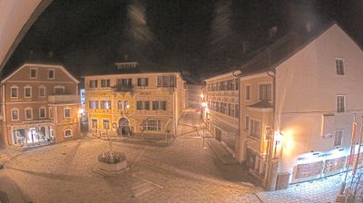


The landscape around Kotschach-Mauthen is an Alpine valley beneath the Carnic Alps, which has shaped both the settlement pattern and local economy. The town lies in the upper Gail Valley of southwestern Carinthia, close to the Italian border and the Plöcken Pass. Mauthen’s name recalls its former function as a toll station on an important route through the mountains. The local Museum 1915–18 documents the First World War battles fought along the nearby Carnic Front, giving the area a tangible link to this contested borderland. Today, the surrounding valleys and high routes define its distinctly Alpine character. Browse other webcams across Carinthia and the Gail Valley to place this setting in a wider geographic context.
4 webcams
Carinthia is best known within Austria for its warm Alpine lakes, especially Lake Wörthersee. Austria’s southernmost province lies along the eastern Alps, where the Drava River runs through broad valleys below mountain slopes. Lake Millstatt and Lake Ossiach provide further waterside focal points, while the rounded Nock Mountains shape much of the interior. Klagenfurt, the provincial capital, is recognised for the Lindwurm fountain on Neuer Platz, a long-standing symbol of the city. Discover other points of interest through webcams located across Carinthia.
322 webcams
Austria stretches from the Bohemian Massif along its northern edge to the Carnic Alps on the Italian border, encompassing high Alpine ranges and the Danube lowlands. The Danube links cities including Linz and Vienna, while the Grossglockner, at 3,798 metres, is the country’s highest mountain. Vienna developed for centuries as the seat of the Habsburg court, leaving imperial architecture around the Hofburg and Schönbrunn Palace. Salzburg is closely associated with Wolfgang Amadeus Mozart, who was born there in 1756. Alpine Tyrol, wine-growing areas east of Vienna and the lakes of Salzkammergut add markedly different regional identities. Browse other webcams across Austria to place this setting in a wider geographic context.
2.9K webcams