 Saint-Pierre: Jetée de la Pointe aux canons
Saint-Pierre straddles a narrow coastal strip on the eastern shore of Île Saint-Pierre in the French archipelago of Saint-Pierre-et-Miquelon, a position that has made it the territory’s principal port and administrative centre. The Jetée de la Pointe aux Canons extends into the North Atlantic beside a low, rocky shoreline protected by stone breakwaters. Saint-Pierre lies south of Newfoundland and forms part of a French overseas collectivity. Its identity has long been tied to the cod fishery, which built the town’s maritime role and continues to shape the character of its waterfront. French is the official language, and the harbour remains central to daily life on the islands.
Generated by AI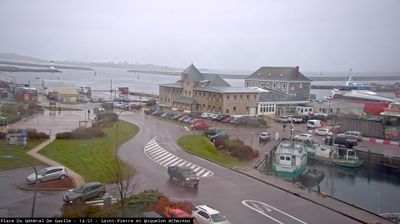




Few communities in the Saint Pierre and Miquelon archipelago have a history as closely tied to the North Atlantic cod fishery as Saint-Pierre. The territory’s administrative centre occupies a sheltered harbour on Saint-Pierre Island, off Newfoundland’s south coast, where French language and institutions set it apart from neighbouring Canada. Its waterfront developed through fishing and maritime trade; during US Prohibition, the islands also became an important liquor-transshipment base. Île aux Marins, across the harbour, recalls the area’s fishing-settlement past. See how Saint-Pierre fits within the wider French archipelago by browsing webcams nearby.
2 webcams
The terrain of Saint Pierre and Miquelon ranges from rocky shores on Saint-Pierre to low heath and dunes on Miquelon-Langlade, creating an exposed North Atlantic setting. This French collectivity lies just south of Newfoundland, yet its language, institutions, and daily life remain distinctly French. Saint-Pierre is the administrative centre and a historic fishing port, while Miquelon-Langlade contains the Grand Barachois lagoon. Cod fishing shaped the islands for generations, and the sea still sets the rhythm of local life. Explore other webcams in the region to compare coastal landscapes and harbour settings around Saint Pierre and Miquelon.
4 webcams
The Atlantic and Mediterranean coastlines, together with the Alps, Pyrenees and broad river basins, define much of France — they support maritime trade, farming, wine regions and travel throughout the year. The Seine runs through Paris, where the Eiffel Tower and the Louvre are among Europe’s most recognised landmarks. The Loire Valley is known for Renaissance châteaux, while Mont-Saint-Michel rises from a tidal bay in Normandy. Regional food traditions are equally distinctive, from Breton seafood to Provençal cooking, with bread, cheese and wine central to everyday life. France’s global cultural influence is evident in its language, literature, fashion and cinema. View additional webcams nearby to better understand how France’s coasts, plains and mountain borders relate to their surroundings.
2.2K webcams