 Peoria Heights
 combines a compact business district with quiet residential blocks in a way that reflects its position on the wooded bluffs above the Illinois River. The village adjoins Peoria within the wider central Illinois urban area, yet its Prospect Road corridor gives it a distinct local center of shops, restaurants and services. Incorporated in 1898, Peoria Heights developed as a separate community along the river bluff rather than as a downtown extension of Peoria. Streets climb and follow the rolling terrain, while mature tree cover and low-rise buildings keep the settlement’s scale noticeably more intimate than that of the neighboring city. The Illinois River remains the defining geographic presence along the western edge of this part of the metro area.
Generated by AI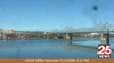


The Illinois River valley defines the setting of Peoria Heights — wooded bluffs above its eastern bank give this village an elevated, residential character beside the city of Peoria. Streets rise away from the river toward established neighbourhoods, while Prospect Road forms the local commercial corridor with independent businesses, restaurants and community services. Tower Park, centred on the village’s prominent water tower, is a familiar landmark and reflects Peoria Heights’ identity as a close-knit Illinois community. Discover other points of interest through webcams located across Peoria Heights and central Illinois.
1 webcam
Illinois has served as a frontier within the United States since the early nineteenth century. Its broad central plains, including the area around Springfield, contrast with the urban scale of Chicago on Lake Michigan. The Mississippi River forms much of the western state boundary, while the Illinois River crosses the interior toward the Mississippi. Springfield is closely associated with Abraham Lincoln, who lived and worked there before becoming president; his home and presidential library are major civic landmarks. Farming remains central to the state’s identity, alongside manufacturing, transport, and the cultural influence of Chicago. Browse additional webcams from the surrounding area to extend your view of Illinois.
53 webcams
The Atlantic, Pacific and Gulf coasts define much of the United States — their ports, fisheries and trade routes have long tied the country’s economy to the wider world. Between them, the Rocky Mountains, Great Plains and Mississippi River basin form sharply different regions, from high western ranges to broad agricultural heartlands. Cities carry much of the national story: New York’s Statue of Liberty, a gift from France dedicated in 1886, remains an enduring symbol, while Washington, DC concentrates major federal institutions. Indigenous nations have shaped these lands for millennia, and their living cultures remain essential to the country’s identity. Find related webcams in the surrounding areas to build a fuller picture of the United States.
32K webcams