 Grao-Para: Altos da Serra do Corvo Branco
The Serra do Corvo Branco defines the setting of Altos da Serra do Corvo Branco — high ridges, forested slopes and open grassland give this part of Santa Catarina a distinctly upland character. It forms part of the Serra Geral escarpment, where Brazil’s southern plateau drops toward the coastal plain. The road across the range links Grão-Pará and Urubici; its imposing rock cutting is a notable piece of mountain-road engineering. Native forest and highland fields meet along the route, while the broad relief sets this area apart from Brazil’s better-known tropical lowlands. Altos da Serra do Corvo Branco introduces the rugged geography of southern Brazil.
Generated by AI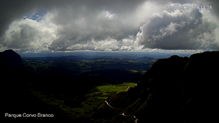

The Rio Braço do Norte defines the setting of Grão-Pará — descending from the Serra Geral, it runs through a small urban centre surrounded by steep slopes and rural districts in southern Santa Catarina. Agriculture remains central to local life, while the mountains quickly take over beyond the built-up streets. Parque Estadual da Serra Furada, shared by Grão-Pará and neighbouring Orleans, protects Atlantic Forest on the Serra Geral escarpment. Grão-Pará became an independent municipality in 1958 after separating from Orleans. See how Grão-Pará connects with southern Santa Catarina by browsing webcams nearby.
1 webcam
Atlantic coastline, remnants of the Atlantic Forest and southern highlands define much of Santa Catarina — their contrasting environments support agriculture, manufacturing, port trade and tourism. Brazil’s southern state stretches from Atlantic beaches to cooler upland areas, where Araucaria forest is an important regional feature. Florianópolis, the state capital, occupies Santa Catarina Island and is closely associated with the coast, while the interior has long been shaped by farming and industry. Azorean traditions remain visible in coastal communities, and German and Italian immigration has strongly influenced food, architecture and local festivals in other parts of the state. Browse additional webcams around Santa Catarina to extend your view of southern Brazil.
14 webcams
Brazil has served as a Portuguese colonial link between Europe and South America since the 16th century. Its immense territory extends from the Amazon River basin in the north to the Atlantic coast, with the Pantanal wetlands and Brazilian Highlands creating very different regions inland. Rio de Janeiro sits beside Guanabara Bay beneath Sugarloaf Mountain, while Brasília is known for its planned layout and modernist buildings by Oscar Niemeyer. Portuguese is the official language, and football, regional cuisines and Carnival celebrations are central to public life across the country. Continue through nearby webcams to explore different parts of Brazil.
149 webcams