 Andrijevica: Jezerine - Ski Kolašin 1450
Lokve Ski Centre lies above the Lim valley, where open mountain pasture rises into dense conifer forest on the slopes of Cmiljevica. This compact winter-sports area occupies Montenegro’s mountainous northeast, near Andrijevica, with a ski lift and service buildings set amid broad clearings rather than an urban resort. The setting reflects the mosaic of meadow and woodland typical of the country’s uplands. Across Montenegro, seasonal grazing has long shaped this terrain; katuns, the temporary summer settlements used by herding families, remain an important part of mountain culture. Lokve provides a small-scale, rural alternative to the country’s larger ski centres.
Generated by AI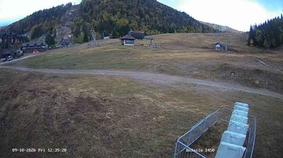


Andrijevica combines the steady pace of a small municipal centre with the rugged terrain of northeastern Montenegro, reflecting its position in the Lim River valley beneath the Komovi mountains. The town is closely associated with the historic Vasojevići region, whose communities have long shaped this part of the country. Its name recalls the Church of St Andrew, built in the 19th century by Duke Miljan Vukov Vešović. Forested slopes and mountain roads lead outward towards the Komovi and Prokletije ranges, making Andrijevica a practical base for exploring Montenegro’s highland interior. Browse webcams nearby to see how Andrijevica belongs within northeastern Montenegro.
1 webcam
Andrijevica Municipality has served as a local administrative centre within northeastern Montenegro since the late 19th century. Its small municipal centre lies in the Lim River valley, where routes between Berane, Plav and the high country meet. The Komovi massif rises to the west, while the wider Prokletije mountain region shapes the horizons and climate of this largely rural area. Andrijevica belongs to the historic Vasojevići region, whose clan traditions remain an important reference point in local identity. Forests, pastureland and scattered settlements give the municipality a distinctly upland character. View additional webcams nearby to better understand how Andrijevica Municipality relates to the Lim valley and Montenegro’s northern mountains.
1 webcam
Montenegro occupies a rugged Adriatic coast and mountainous interior in southeastern Europe. The Bay of Kotor cuts deep into the shore beneath steep slopes, while Durmitor National Park protects high Dinaric terrain and the Tara River canyon. Kotor’s fortified old town, shaped during centuries of Venetian rule, is a UNESCO World Heritage site; its lanes and squares contrast with the beaches around Budva. Inland, Lake Skadar forms part of the border with Albania and supports an important wetland ecosystem. Orthodox monasteries, Ottoman-era traces and a strong café culture reflect the country’s layered past. Find related webcams in the surrounding area to build a fuller picture of Montenegro’s coast and mountains.
12 webcams