 Las Mercedes: Volcán San Cristóbal - Chinandega, Nicaragua
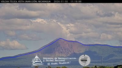
The landscape around San Cristóbal Volcano is a cultivated volcanic plain rising to a steep stratovolcanic cone, which has shaped both the built environment and local life. At 1,745 metres, San Cristóbal is Nicaragua’s highest volcano and the dominant summit of the Cordillera Los Maribios in the country’s northwest. Its fertile soils support the agricultural economy of Chinandega Department, where sugar cane, peanuts and other crops are grown across the lowlands. The volcano remains active, an enduring reality for communities on its flanks and for Nicaragua’s volcanic monitoring. Las Mercedes lies in this productive Pacific-side region, while León to the southeast is one of the country’s principal colonial cities.
Generated by AI

Las Mercedes occupies Nicaragua’s Pacific lowlands in the department of Chinandega. This western part of the country extends between the Pacific Ocean and the inland volcanic belt, with a warm tropical climate and broad agricultural terrain. Chinandega is one of Nicaragua’s important farming regions, particularly associated with crops such as sugar cane, peanuts and sesame. Las Mercedes reflects the quieter rural side of a department whose larger towns connect local producers with the country’s Pacific coast. Explore nearby webcam locations that provide complementary perspectives on Chinandega’s Pacific lowlands.
1 webcam
Chinandega occupies the Pacific lowlands of northwestern Nicaragua. Its departmental capital stands on a fertile plain west of the Cordillera Los Maribios, dominated by San Cristóbal, Nicaragua’s highest volcano. Sugar cane and peanuts are among the region’s important crops, shaping the economy of the city and surrounding towns. In central Chinandega, the Basilica of Santa Ana is a prominent Catholic landmark. The department extends west toward the Pacific coast, while the Gulf of Fonseca lies farther north near the Honduran border. Continue with other webcams from the area to see how this part of northwestern Nicaragua connects regionally.
1 webcam
Lake Nicaragua defines much of Nicaragua — its waters support fishing and local transport, while the volcanic island of Ometepe rises from its southern basin. The Pacific side brings together volcanoes, fertile farming districts and the colonial cities of Granada and León; Granada was founded in 1524 and retains a historic centre of colourful facades and churches. On the Caribbean coast, the Corn Islands and the Miskito Coast belong to a distinctly different, sea-facing world. Coffee is a major agricultural export, and Indigenous and Afro-descendant traditions contribute to the country’s cultural fabric. View additional webcams nearby to better understand how Nicaragua’s lakes, coasts and volcanic interior relate to their surroundings.
7 webcams