 Lopata: Dolina Chochołowska kamera TOPR
The landscape around Dolina Chochołowska is a deep, forested valley in the Western Tatras, which has shaped both the built environment and local life. The Chochołowski Potok runs through this part of Tatra National Park, beneath steep slopes and ridges of the Polish-Slovak mountain border. Woodland dominates the lower valley, while open clearings, known locally as polanas, reflect the long pastoral traditions of Podhale. Sheep grazing has helped maintain these meadow spaces for generations. Farther into the valley, Polana Chochołowska is home to a PTTK mountain hut and forms an established base for walkers exploring the Western Tatras.
Generated by AI



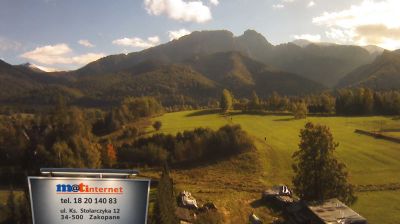





The loess-covered Opatów Upland defines the setting of Lopata — gently rolling farmland and small valleys shape the settlement’s rural pace in the eastern part of Holy Cross Voivodeship. This is agricultural country, where open fields sit between scattered hamlets rather than dense urban development. Lopata belongs to Opatów County, an area associated with historic Lesser Poland. In the county town of Opatów, the Romanesque Collegiate Church of St Martin, founded in the 12th century, preserves one of the region’s notable medieval monuments. Explore other webcams in Holy Cross Voivodeship to compare the upland countryside and historic towns around Opatów.
1 webcam
The terrain of Holy Cross Voivodeship ranges from the forested Świętokrzyskie Mountains in its north-central belt to the limestone hills and river valleys of the Nida Basin in the south, giving the region a compact but varied inland character. Łysica, at 614 metres, is the highest point of the Świętokrzyskie Mountains, while the Nida flows through a quieter agricultural district. Kielce, the voivodeship capital, is home to the 17th-century Palace of the Kraków Bishops. The Holy Cross monastery on Łysa Góra gave the region its name and remains a defining spiritual landmark. Continue with other webcams from the area to see how this part of south-central Poland connects regionally.
20 webcams
Poland stretches from the Baltic Sea coast in the north to the Carpathian Mountains along its southern frontier, encompassing broad lowlands, lake districts and upland ranges. The Vistula, the country’s longest river, links Kraków and Warsaw before reaching the Baltic near Gdańsk, while the Masurian Lake District is defined by a dense network of lakes. Kraków’s historic centre, including Wawel Castle, recalls Poland’s former royal capital; Warsaw’s rebuilt Old Town speaks to the city’s recovery after the Second World War. The Białowieża Forest preserves one of Europe’s last primeval lowland forests and is home to European bison. Follow how Poland’s regions relate to one another by browsing webcams across the country.
717 webcams