 Swakopmund
 sits on Namibia’s Atlantic coast in the Erongo Region, where the Namib Desert meets the sea. Founded in 1892 as a port for German South West Africa, it retains an urban character markedly different from most Namibian towns, with German colonial-era buildings alongside broad coastal streets. The Swakop River reaches the Atlantic immediately south of the town, separating its built-up edge from the dunes of the Namib. The historic Swakopmund Jetty extends from the seafront into the ocean and remains a familiar landmark of this coastal resort. Today, Swakopmund is a base for exploring the central Namib coast, linking beach walks, fishing and waterfront dining with the town centre.
Generated by AI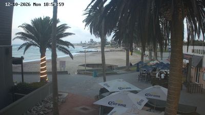

Swakopmund straddles the boundary between the Namib Desert and the Atlantic Ocean in Namibia’s Erongo Region, a position that established it as a German colonial port and still gives the town its markedly cool, coastal character. The usually dry Swakop River reaches the sea just south of the centre, while dunes and gravel plains extend inland from its streets. German-era landmarks such as the Woermannhaus and Hohenzollernhaus recall the town’s founding in 1892. Today, Swakopmund is a base for exploring the Namib’s shifting sands, Atlantic shoreline and nearby desert landscapes. Browse other webcams across the Erongo Region to place Swakopmund’s coast-and-desert setting in a wider geographic context.
2 webcams
Built around Atlantic ports, desert mining and inland ranching, Erongo Region developed into one of Namibia’s principal economic regions. Its western edge meets the Atlantic Ocean, while the Namib Desert extends inland toward the granite domes of the Erongo Mountains and the distinctive Spitzkoppe. The Swakop River crosses this dry country, its episodic flow sustaining a narrow corridor of vegetation near the coast. Swakopmund, established in 1892 as a German colonial port, remains the region’s best-known town, marked by period architecture and a seaside setting. Walvis Bay, Namibia’s main deep-water harbour, brings a working maritime character, while Arandis reflects the importance of uranium mining. Browse other webcams across Erongo Region to place its desert coast and mountains in a wider Namibian context.
2 webcams
Namibia is best known internationally for the Namib Desert and the red dunes surrounding Sossusvlei. Along the Atlantic, the Skeleton Coast links fog-bound shores with an exceptionally dry interior, while Etosha National Park centres on a vast salt pan where wildlife congregates at waterholes during the dry season. In the south, the Fish River Canyon cuts through arid terrain; farther north-west, Damaraland is noted for desert-adapted elephants and rock formations. Twyfelfontein preserves prehistoric rock engravings and is a UNESCO World Heritage Site. Windhoek, the capital, is the country’s administrative and transport hub. View additional webcams nearby to better understand how Namibia’s desert regions relate to the Atlantic coast and inland plateaus.
6 webcams